Historical Markers

Shea's Videos and Travel Journal Entries Tagged with Historical Markers

The Laurentian Divide
I pulled over at a rest stop to stretch my legs and eat an apple (with peanut butter, of course!) and ended up learning more geography about northern Minnesota.
Nestled in Whipholt Roadside Park, a stone monument with a plaque commemorates the Battle of Sugar Point while overlooking a calm, blue lake under a clear sky.
Not that far from Walker, I got one last look at Leech Lake and learned about the last major conflict between the United States and Native Americans.
A person with glasses and curly hair smiles at the camera in front of a rocky waterfall at Falls Park, with buildings in the background, in Sioux Falls, SD.
Driving through Sioux Falls, I had to stop and see the waterfalls and park. Plus, the park has a multi-story observation tower that provides a panoramic view of the falls and city.
A small trailer is set up next to a black Jeep on a grassy field with a tree providing shade, reminiscent of a peaceful park in Scotland. A blue van is parked in the background under a clear sky.
After a disappointing day in Yankton, SD, I needed a place with high-speed Internet to do a few days of work. I was hoping that Scotland would be interesting but...
A historical marker in Nebraska titled "Columbus Powerhouse" provides information about the local landmark. The marker is situated on a green lawn with trees and power lines in the background, creating an picturesque scene.
The Columbus Powerhouse is Nebraska's largest hydroelectric plant. Funded by a New Deal grant, it provided jobs during the Depression and supports local industrial development.
A bronze sculpture depicting a person plowing with a horse takes center stage on a wooden cabinet at the Platte Valley Historical Society Museum. Capturing mid-movement action, signs urge "Please Do Not Touch," while framed documents adorn the wall behind, enriching the historical narrative.
After getting a little bit of work done, I decided to head into town and check out the local history. The Platte Valley Historical Society has done a fantastic job preserving area history.
A rural roadside scene in Saline County reveals an expansive grassy field under a cloudy sky. A blue road sign stands near a gravel shoulder, next to a tall historic marker. Power lines run parallel to the road, stretching into the distance beside the green farmland.
It's not every day that you're driving down a rural highway and see a historical marker that is an obelisk. Still, I found one dedicated to the Bohemian settlers of this region.
A mural on a white brick building in Wilber, Nebraska, titled "Czech Capital of the USA," features Czech dancers, an American flag, and local landmarks. Decorative scrolls and symbols border the artwork. In front lies a cracked asphalt parking lot, adding to its rustic charm.
Wilbur is one of the many small towns I've rolled into, and I wish I had more time to explore it. However, having a few minutes to walk around was still cool and interesting.
A historical marker stands in a grassy field with farmland stretching into the distance under a cloudy sky. Titled "Swan City," it provides insight into the area's settlement history in Nebraska. A line of trees gracefully borders the far edge of this picturesque scene.
It's always weird to come across a historical marker for a town that was historically significant at one time but now no longer exists, and no trace of the city remains at all.
A black Jeep with a rooftop cargo carrier is towing a small teardrop camper on a gravel path in front of the historic Filley Stone Barn, known for its striking red doors and windows. The overcast sky lends a moody atmosphere, while scattered trees pepper the grassy field in the background.
It's not too often that a barn makes it as a marker on Google Maps, so when this was on my route, I had to take a few minutes to check it out.
A historical marker titled "Battle of the Spurs" stands in a grassy area in Kansas, framed by a cloudy sky in the background.
The "Battle of the Spurs" in January 1859, where John Brown led 11 slaves to freedom. U.S. Marshals tried to capture him, but Brown's defiance led to the slaves' successful escape.
A historical marker stands in a grassy Kansas field, detailing the history of The Lane Trail, which was used to aid Free-Staters and help transport slaves to freedom. Trees and a cloudy sky provide a serene backdrop.
Established in 1856, the Lane Trail bypassed proslavery Missouri to aid free-state settlers. Marked by "Lane's Chimneys," it extended from Iowa to Topeka as part of the Underground Railroad.
A historic cannon with large wooden wheels is displayed on a wooden platform, set on a grassy field with historical buildings in the background.
An unexpected hidden gem of a national historic site! Like all sites in the national Park system this one is unbelievably well done and even has a full-time blacksmith.
A historical marker titled "Discoverer of Pluto" stands proudly on the grassy roadside. Behind it, a small teardrop trailer waits, hitched to a vehicle under the partly cloudy sky. Trees gently line the road, bearing witness to Clyde Tombaugh's monumental discovery of Pluto.
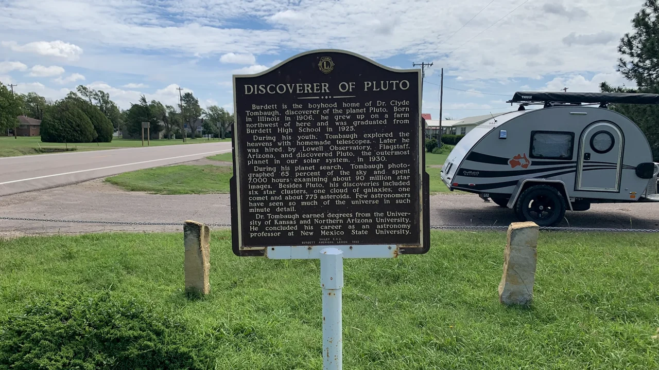
Historical Marker for Dr. Clyde Tombaugh, from Burdett, Kansas, discovered Pluto in 1930. He also found a comet, six star clusters, a galaxy cloud, and 775 asteroids.
A historic stone building with arched windows and a tower stands at a corner intersection under a clear blue sky.
I simply love stopping in cool little towns that have unique character. The bank building here is absolutely beautiful and needed to be photographed and added to my blog.
A brown historical marker titled "Homestead of a Genius" stands on a grassy field under a clear sky, displaying text about a noted figure's birthplace and achievements.
Rolling down the highway, I see another historical marker. I had totally forgotten that George Washington Carver had homesteaded in Kansas before he became famous.